File:Un-palau.png

ʻAsi ʻa e faitā auiiki ((1,432 × 1,909 meʻaʻata, ko e faile hono lahi: 357 KB, faʻahinga MIME: image/png))
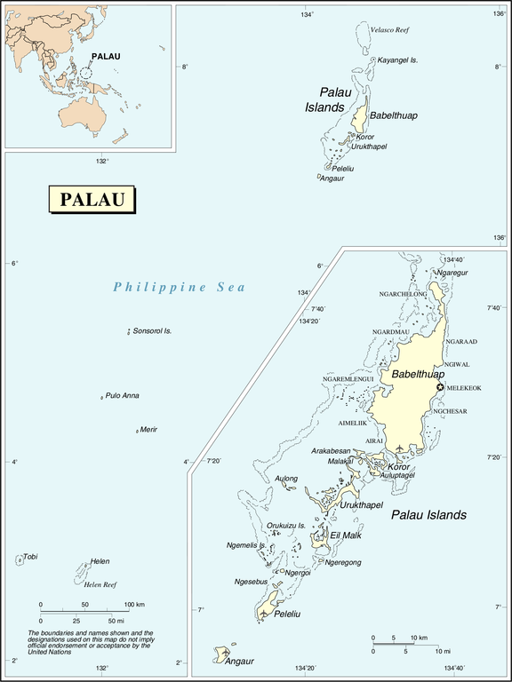
| This image is a map derived from a United Nations map.
Unless stated otherwise, UN maps are to be considered in the public domain. This applies worldwide. UN maps are, in principle, open source material and you can use them in your work or for making your own map. UN requests however that you delete the UN name, logo and reference number upon any modification to the map. Content of your map will be your responsibility. You can state in your publication, if you wish, something like: based on UN map … (map name, map number, revision number and date). See: Geospatial Information Section. And: Geospatial, location data for a better world. |
 |
Hisitōlia ʻo e faile
Lomiʻi ha ʻaho/taimi ki he vakai ʻo e faile naʻe ʻi ai he taimi ko iá.
| ʻAho/Taimi | ʻAtasiʻi | Hono lahi | ʻEtita | Fakamatala | |
|---|---|---|---|---|---|
| taka | 22:11, 25 ʻOkatopa 2007 | | 1,432 × 1,909 (357 KB) | Jeroen | Changed the location of the capital to the new capital and fixed the location in the area of the old capital. |
| 01:58, 24 ʻOkatopa 2007 |  | 1,432 × 1,909 (358 KB) | Jeroen | {{UN map}} Category:Maps of Palau |
Faitā fehokotaki
ʻOku fehokotaki ʻa e ngaahi peesi ki he failé ni:
Global file usage
The following other wikis use this file:
- Usage on ast.wikipedia.org
- Usage on avk.wikipedia.org
- Usage on en.wikipedia.org
- Usage on fr.wikipedia.org
- Usage on fy.wikipedia.org
- Usage on gom.wikipedia.org
- Usage on km.wikipedia.org
- Usage on nl.wikipedia.org
- Usage on no.wikipedia.org
- Usage on pl.wiktionary.org
- Usage on uk.wikipedia.org