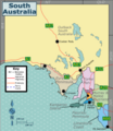
File:South Australia regions map.png

Size of this preview: 519 × 599 pixels. Other resolutions: 208 × 240 pixels | 416 × 480 pixels | 665 × 768 pixels | 887 × 1,024 pixels | 1,773 × 2,048 pixels | 5,628 × 6,500 pixels.
ʻAsi ʻa e faitā auiiki ((5,628 × 6,500 meʻaʻata, ko e faile hono lahi: 2.42 MB, faʻahinga MIME: image/png))
Hisitōlia ʻo e faile
Lomiʻi ha ʻaho/taimi ki he vakai ʻo e faile naʻe ʻi ai he taimi ko iá.
| ʻAho/Taimi | ʻAtasiʻi | Hono lahi | ʻEtita | Fakamatala | |
|---|---|---|---|---|---|
| taka | 13:25, 25 Sune 2023 |  | 5,628 × 6,500 (2.42 MB) | SHB2000 | {{Information |Description=A map of {{w|South Australia}} with its regions used on its respective Wikivoyage article. |Source={{own}}, except for * Boundaries: File:Australia South Australia map.png * Outline: OpenStreetMap |Date=202306-25 |Author=SHB2000 |Permission= |other_versions=SVG file }} Category:Travel maps of Australia Category:Wikivoyage maps of South Australia by SHB2000 [[Category:M... |
Faitā fehokotaki
ʻOku ʻikai ha ngaahi peesi fehokotaki ki he faitā ni.
Global file usage
The following other wikis use this file:
- Usage on en.wikivoyage.org
- Usage on fr.wikivoyage.org
- Usage on it.wikivoyage.org