File:Netherlands-CIA WFB Map.png
ʻOku ʻikai ʻi ai ha faitā auiiki.
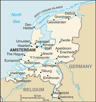
Netherlands-CIA_WFB_Map.png ((330 × 353 meʻaʻata, ko e faile hono lahi: 65 KB, faʻahinga MIME: image/png))
| Fakamahino | Map of the Netherlands |
| Tupunga | CIA World Factbook |
| Author | CIA |
| Other versions |
Derivative works of this file: Netherlands-CIA WFB Map-10-10-10.png Dutch; Norwegian; English (2004) |
.png)
This image is in the public domain because it contains materials that originally came from the United States Central Intelligence Agency's World Factbook.
|
 |
Hisitōlia ʻo e faile
Lomiʻi ha ʻaho/taimi ki he vakai ʻo e faile naʻe ʻi ai he taimi ko iá.
| ʻAho/Taimi | ʻAtasiʻi | Hono lahi | ʻEtita | Fakamatala | |
|---|---|---|---|---|---|
| taka | 16:35, 14 Sēpitema 2019 | | 330 × 353 (65 KB) | Thayts | Borkum to Germany |
| 02:28, 26 Siulai 2008 |  | 330 × 353 (21 KB) | Hoshie | updated map of Netherlands from the CIA World Factbook - 24 July 2008 edition: https://www.cia.gov/library/publications/the-world-factbook/maps/nl-map.gif | |
| 09:16, 27 Maʻasi 2005 |  | 330 × 355 (10 KB) | Wolfman~commonswiki | {{CIA-map}} |
Faitā fehokotaki
ʻOku ʻikai ha ngaahi peesi fehokotaki ki he faitā ni.
Global file usage
The following other wikis use this file:
- Usage on ar.wikipedia.org
- Usage on de.wikipedia.org
- Usage on en.wikipedia.org
- Usage on en.wikisource.org
- Usage on eu.wikipedia.org
- Usage on gag.wikipedia.org
- Usage on he.wikipedia.org
- Usage on hu.wikipedia.org
- Usage on hu.wiktionary.org
- Usage on ka.wikipedia.org
- Usage on mr.wikipedia.org
- Usage on pl.wikipedia.org
- Usage on pt.wikipedia.org
- Usage on ru.wikipedia.org
- Usage on sq.wikipedia.org
- Usage on zh.wikipedia.org