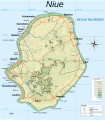
File:Carte topographique de Niue.svg

Size of this PNG preview of this SVG file: 526 × 599 pixels. Other resolutions: 211 × 240 pixels | 421 × 480 pixels | 674 × 768 pixels | 899 × 1,024 pixels | 1,798 × 2,048 pixels | 1,760 × 2,005 pixels.
ʻAsi ʻa e faitā auiiki ((Faile SVG, lau pē 1,760 × 2,005 meʻaʻata, ko e faile hono lahi: 332 KB))
Hisitōlia ʻo e faile
Lomiʻi ha ʻaho/taimi ki he vakai ʻo e faile naʻe ʻi ai he taimi ko iá.
| ʻAho/Taimi | ʻAtasiʻi | Hono lahi | ʻEtita | Fakamatala | |
|---|---|---|---|---|---|
| taka | 20:53, 2 Sune 2010 |  | 1,760 × 2,005 (332 KB) | Cj73 | Suppression titre de la carte |
| 18:15, 2 Sune 2010 |  | 1,760 × 2,005 (332 KB) | Cj73 | Divers retouches | |
| 16:36, 2 Sune 2010 |  | 1,760 × 2,006 (340 KB) | Cj73 | ({{Information |Description= Carte topographique de Niue |Source=Округа_Ниуэ.svg |Date=1 juin 2010 |Author=Cj73 |Permission= |other_versions= }}) | |
| 22:23, 1 Sune 2010 |  | 1,760 × 2,006 (356 KB) | Cj73 | {{Information |Description= Carte topographique de Niue |Source=Округа_Ниуэ.svg |Date=1 juin 2010 |Author=Cj73 |Permission= |other_versions= }} | |
| 21:29, 1 Sune 2010 |  | 1,760 × 2,006 (352 KB) | Cj73 | ({{Information |Description={{ru|Административное деление Ниуэ.<br/> Категория:Ниуэ}} |Source=*File:Округа_Ниуэ.svg |Date=2010-06-01 21:22 (UTC) |Author=*File:Округа_Ниуэ.svg: Переход Ар | |
| 21:26, 1 Sune 2010 |  | 1,760 × 2,006 (352 KB) | Cj73 | {{Information |Description={{ru|Административное деление Ниуэ.<br/> Категория:Ниуэ}} |Source=*File:Округа_Ниуэ.svg |Date=2010-06-01 21:22 (UTC) |Author=*[[:File:О |
Faitā fehokotaki
ʻOku fehokotaki ʻa e ngaahi peesi ki he failé ni:
Global file usage
The following other wikis use this file:
- Usage on avk.wikipedia.org
- Usage on en.wikisource.org
- Usage on eo.wikipedia.org
- Usage on fi.wikipedia.org
- Usage on fr.wikipedia.org
- Usage on incubator.wikimedia.org
- Usage on it.wikipedia.org
- Usage on lt.wikipedia.org
- Usage on nl.wikipedia.org
- Usage on pl.wikipedia.org
- Usage on pl.wiktionary.org
- Usage on sv.wikipedia.org
- Usage on uk.wikipedia.org
- Usage on www.wikidata.org