File:Afghanistan physical en.png

Size of this preview: 768 × 600 pixels. Other resolutions: 307 × 240 pixels | 615 × 480 pixels | 983 × 768 pixels | 1,280 × 1,000 pixels | 2,079 × 1,624 pixels.
ʻAsi ʻa e faitā auiiki ((2,079 × 1,624 meʻaʻata, ko e faile hono lahi: 4.46 MB, faʻahinga MIME: image/png))
Fakanounou
| Fakamahino |
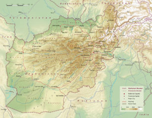
Physical map of Afghanistan, administrative division into 34 provinces following the administrative reform from 2005. (Here is one more map, not on commons, on www.ezilon.com/maps: Physical Map of Afghanistan) |
| Date | |
| Tupunga | Selfmade, based on topographic data: SRTM30 V2.1 |
| Author | User:Sommerkom |
| Other versions |
|

Laiseni:
I, the copyright holder of this work, hereby publish it under the following license:
This file is licensed under the Creative Commons Attribution-Share Alike 3.0 Unported license.
- You are free:
- to share – to copy, distribute and transmit the work
- to remix – to adapt the work
- Under the following conditions:
- attribution – You must give appropriate credit, provide a link to the license, and indicate if changes were made. You may do so in any reasonable manner, but not in any way that suggests the licensor endorses you or your use.
- share alike – If you remix, transform, or build upon the material, you must distribute your contributions under the same or compatible license as the original.
Hisitōlia ʻo e faile
Lomiʻi ha ʻaho/taimi ki he vakai ʻo e faile naʻe ʻi ai he taimi ko iá.
| ʻAho/Taimi | ʻAtasiʻi | Hono lahi | ʻEtita | Fakamatala | |
|---|---|---|---|---|---|
| taka | 12:43, 10 Sēpitema 2010 | | 2,079 × 1,624 (4.46 MB) | Sommerkom | == Beschreibung, Quelle == {{Information |Beschreibung = Physical map of Afghanistan, administrative division into 34 provinces following the administrative reform from 2005. |Quelle = Selfmade, topographic data: [http://www2.jpl.nasa.gov/srtm/index.html |
Faitā fehokotaki
ʻOku fehokotaki ʻa e ngaahi peesi ki he failé ni:
Global file usage
The following other wikis use this file:
- Usage on af.wikipedia.org
- Usage on ar.wikipedia.org
- Usage on ast.wikipedia.org
- Usage on bcl.wikipedia.org
- Usage on bg.wikipedia.org
- Usage on ckb.wikipedia.org
- Usage on de.wikipedia.org
- Usage on en.wikipedia.org
- Usage on es.wikipedia.org
- Usage on fr.wikipedia.org
- Usage on hu.wikipedia.org
- Usage on hy.wikipedia.org
- Usage on ja.wikipedia.org
- Usage on ka.wikipedia.org
- Usage on ko.wikipedia.org
- Usage on lo.wikipedia.org
- Usage on lv.wikipedia.org
- Usage on mt.wikipedia.org
- Usage on my.wikipedia.org
- Usage on or.wikipedia.org
- Usage on pl.wikipedia.org
- Usage on sd.wikipedia.org
- Usage on tay.wikipedia.org
- Usage on te.wikipedia.org
- Usage on uk.wikipedia.org
- Usage on ur.wikipedia.org
- Usage on vi.wikipedia.org
- Usage on zh.wikipedia.org